Updated File. Is this still worth doing? WY, UT and NV (not 100% yet still in progress) Found a few "passive repeaters" Big walls in the woods that might be of interest.
| Attachments: |
|
Downloaded 364 times |
| InterceptRadio.com Forums http://www.interceptradio.com/bbs/ |
|
| a little mapping project http://www.interceptradio.com/bbs/viewtopic.php?f=39&t=8243 |
Page 1 of 1 |
| Author: | safetysaurus [ Sun Oct 11, 2015 8:16 am ] |
| Post subject: | a little mapping project |
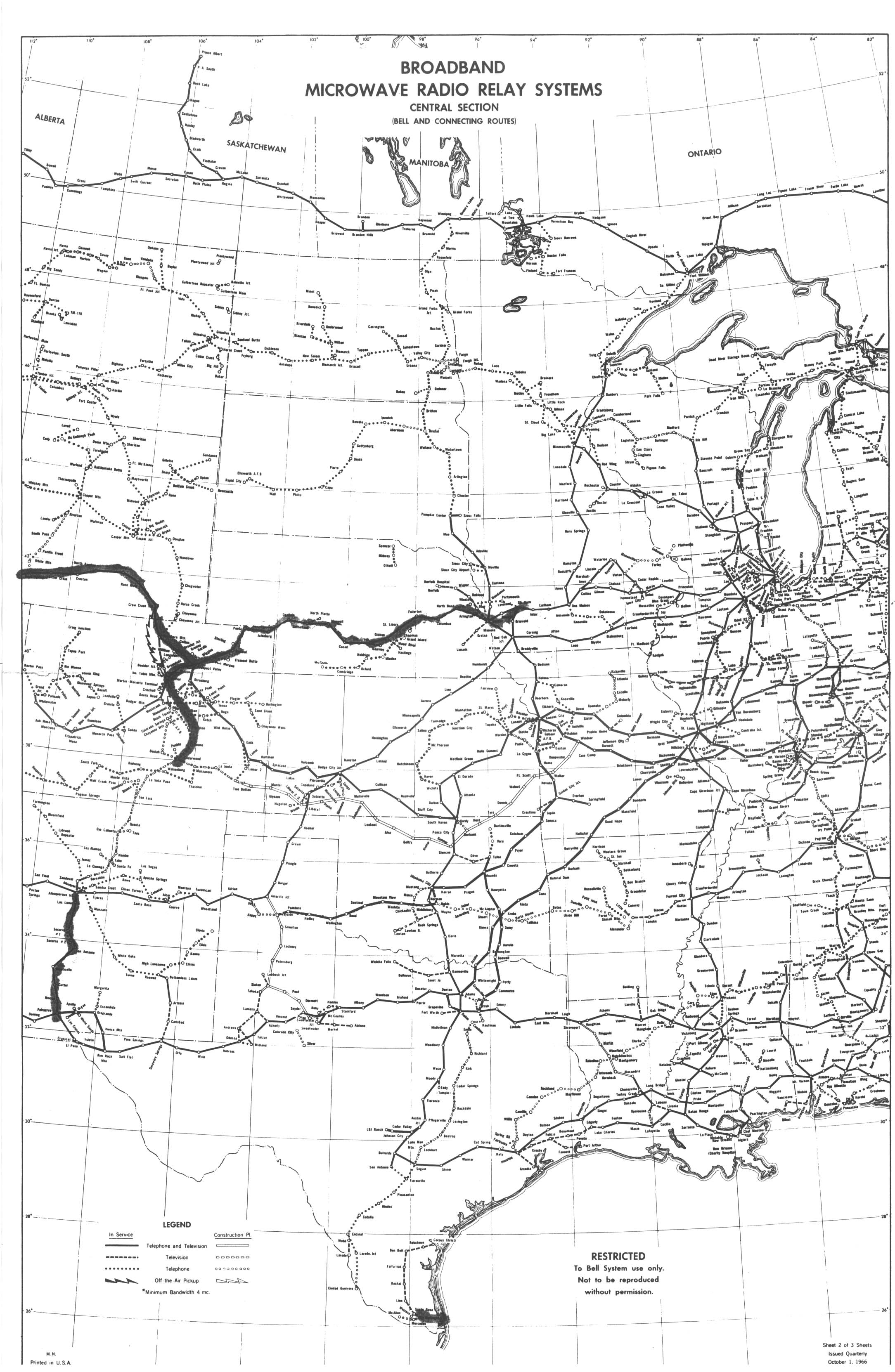
Soo a little while ago I started a little quest to Map out some of the long lines based on a few old posts MikeGilbert’s photos talking about Raven’s roost, and a few other pics. http://www.interceptradio.com/bbs/search.php?keywords=long+lines&terms=all&author=&sc=1&sf=all&sk=t&sd=d&sr=posts&st=0&ch=300&t=0&submit=Search So I started with http://long-lines.net/places-routes/ and I was just eyeballing what I knew of my area and went out from there. Digging around I found another decent site http://www.badpixels.com/jm3000/sites/AT/index.html the CSV data file proved to be helpful, and then http://n3tuq.com/longlines/ which I’m pretty sure got the info from the previous link It helped a lot. Interesting enough I found that http://www.skyvector.com helped a bit with the VFR sectionals. (a handy site to have as well) Anyways I’ve got a fair amount of WA, OR, ID, MT and starting WY. Some of the sites may not show on the most current Ortho Photos on Google Earth, thankfully some of the older Ortho’s show what is now gone or confirmed a building or tower foot print. Hope you enjoy and let me know what you think, If you have feedback or want to contribute that would be helpful as well. |
|
| Author: | jrw14493 [ Sun Oct 11, 2015 9:01 am ] |
| Post subject: | Re: a little mapping project |
I have about a dozen pictures inside and out of the Bethel Ridge site. Where should I submit them? |
|
| Author: | Rich [ Sun Oct 11, 2015 11:53 am ] |
| Post subject: | Re: a little mapping project |
jrw14493 wrote: I have about a dozen pictures inside and out of the Bethel Ridge site. Where should I submit them? Create a Bethel Ridge topic here and upload them or create a Bethel Ridge page on the wiki. One nice thing about using the forums vs. the wiki is that its easier for people to add comments/discussion on the forums. |
|
| Author: | safetysaurus [ Mon Oct 26, 2015 3:40 pm ] | ||
| Post subject: | Re: a little mapping project | ||
Updated File. Is this still worth doing? WY, UT and NV (not 100% yet still in progress) Found a few "passive repeaters" Big walls in the woods that might be of interest.
|
|||
| Author: | w1wso [ Wed Nov 04, 2015 4:33 pm ] |
| Post subject: | Re: a little mapping project |
safetysaurus wrote: Updated File. Is this still worth doing? WY, UT and NV (not 100% yet still in progress) Found a few "passive repeaters" Big walls in the woods that might be of interest. Definitely worth doing. I've got pictures of some WYO sites. |
|
| Author: | safetysaurus [ Tue Jan 05, 2016 2:27 pm ] | |||
| Post subject: | Re: a little mapping project | |||
Here are a few more states that I've had time to work on, they are individual state and Path files
|
||||
| Author: | safetysaurus [ Tue Jan 05, 2016 2:29 pm ] | |||
| Post subject: | Re: a little mapping project | |||
a few more for your enjoyment. I had a big hiccup with storing the last files and will get back to a larger master file eventually It's just going to take some time.
|
||||
| Author: | safetysaurus [ Tue Jan 05, 2016 2:31 pm ] | |||
| Post subject: | Re: a little mapping project | |||
and the last for now... enjoy
|
||||
| Author: | safetysaurus [ Wed Jan 27, 2016 4:23 pm ] | |||
| Post subject: | Re: a little mapping project | |||
I've been trying to find the last little bits of MI and have been a little busy and also kinda hitting dead ends. If you have time take a look for a few of the sites that still remain. http://long-lines.net/places-routes/maps/Detroit_MI-0170.html http://long-lines.net/places-routes/maps/MW6610-C.jpg This one has a mix of the old AT&T trunk for the lack of a better term, and some MI Bell sites added.
|
||||
| Author: | mikegilbert [ Mon Feb 01, 2016 12:28 am ] |
| Post subject: | Re: a little mapping project |
Awesome project! The n3tuq site helped fill in a few missing links. For some reason, Texas has disappeared from the map. I did most of the West coast on this map. You can download data if you log into google. https://www.google.com/maps/d/viewer?mid=z5NtUMEoVhTw.kdRHyoyqygI8 |
|
| Author: | safetysaurus [ Mon Feb 01, 2016 4:19 pm ] | ||
| Post subject: | Re: a little mapping project | ||
updated the file, addition work in NE Montana and a few other spots. Some speculations in a few other areas.
|
|||
| Page 1 of 1 | All times are UTC - 8 hours |
| Copyright © 2013 Interceptradio.com |
|